Honestly, Peak District walks offer some of the most absolutely stunning landscapes you can find anywhere in the UK. We’re talking a massive 555 square miles of incredibly varied terrain! I’ve personally spent so many happy hours wandering through this natural wonderland, and with 1,867 miles of rights of way, there’s a perfect path for every single hiker, no matter your ability.
When you explore the best walks in the Peak District, you’re in for such a treat. You’ll stumble upon everything from ancient, magical woodlands to wild, windswept ridges. The park’s rich history just adds another layer of awesome to these adventures – just picture the famous 1932 mass trespass on Kinder Scout that helped secure the countryside access rights we all enjoy today. It’s incredible! Plus, lots of the Peak District circular walks show off unique features like the 1,000-year-old Saxon crosses you can spot on the Dovedale Stepping Stones route, or the amazing five-arch viaduct from way back in the 1800s along the Monsal Dale walk. And here’s a quirky one for you – the 5.8-mile Roaches circular walk takes you through an area that was once home to wild wallabies! Can you believe it?
So, whether you’re after family-friendly paths that are easy on little legs, or you’re ready for more challenging hikes like conquering Kinder Scout’s summit at a whopping 636 metres, I’ve put together this guide to the top Peak District walks that I promise will genuinely take your breath away. And if you’re planning to make a proper adventure of it over a few days, the park handily offers eight Youth Hostels, which make super comfy bases for all your explorations.
Mam Tor: The Shivering Mountain’s Magnificent Views
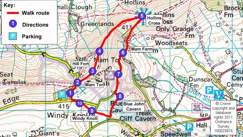
Image Source: National Trust
Standing proudly at 517 metres (that’s 1,696 feet!) above sea level, Mam Tor is a real icon. It’s lovingly known as the “Shivering Mountain” because of the way its eastern face often has little landslides. This famous hill offers some of the most magnificent Peak District walks, with brilliant options for whatever kind of hiking adventure you’re after.
Mam Tor: Distance and Duration of Walks
The great thing about Mam Tor is its versatility. You’ve got a few circular routes to pick from, so you can choose what suits you best:
- Short Mam Tor circular: This one’s a lovely 3-mile (4.8km) route that I’ve found takes about 2 hours. It’s pretty much perfect if you’ve got young children with you.
- Castleton circular route: This option is a bit longer, around 5-7 miles (8-11km), and will probably take you about 2.5-3 hours.
- Edale circular route: This one is 7.4km and you should allow about 2 hours and 20 minutes for it.
Plus, if you’re after something quicker, the direct climb from Mam Nick car park right to the summit is only 550 metres! It’s nice and accessible even if you’re just a casual walker. For those of you wanting a bit more of a challenge, the path stretches out along the Great Ridge, so you can easily make your Peak District walks here longer if you fancy.
Mam Tor: Highlights You Won’t Want to Miss
Honestly, the views from the summit are just incredible – definitely some of the best in the whole Peak District National Park. On a clear day, you can see for miles over the Edale Valley to Kinder Scout, across the Hope Valley, and sometimes even as far as Manchester!
This hill is steeped in history too. It was the site of an Iron Age hillfort built about 3,000 years ago! As you explore, you’ll also pass by famous spots like the Blue John Cavern and Treak Cliff Cavern, which add a bit of fascinating local culture to your hike. If you’re exploring the area, you might find it as captivating as some of the historical spots on Day Trips from London!
Mam Tor: Terrain and Difficulty
I’d generally say this is a moderate walk. The main paths are well-looked-after, but there are a few bits that will get your legs working. The stone-flagged path from Mam Nick car park has some steep climbs and steps, but most parts are fine for anyone who’s reasonably fit.
Just a heads up, when the weather’s wet, the paths can get a bit slippery. This is especially true along the Great Ridge where the flagstones can be pretty treacherous in winter. Depending on which route you pick, the total climb is between 239 metres for the shorter walks, and over 500 metres for the longer ones, so decent footwear is a must.
It’s usually pretty windy up on the ridge, so I’d definitely recommend bringing some warm layers, even if the path is easy to follow. My top tip? Try to visit early in the morning to dodge the crowds, as the car parks (like Mam Nick) fill up super quickly, often by 9 am, especially when it’s busy.
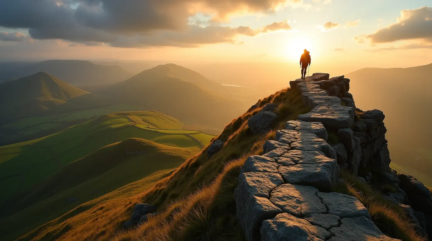
Kinder Scout: The Peak District’s Majestic High Point
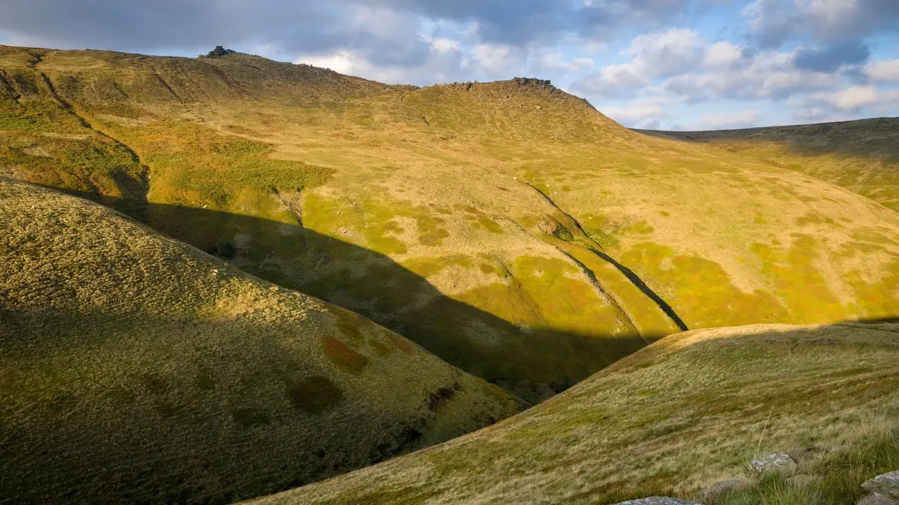
Image Source: National Trust
Wow, at a towering 636 metres (that’s a whopping 2,087 feet!), Kinder Scout proudly reigns as the highest point in the whole of the Peak District. Trust me, it offers some of the most rewarding, yet pretty challenging, Peak District walks you can find. This magnificent moorland plateau is just brimming with natural beauty and has a really important historical significance too, making it an absolute must-visit if you ask me.
Kinder Scout: How Long Will Your Walk Take?
The circular routes around Kinder Scout usually range from about 8 to 14 kilometres (that’s roughly 5 to 8.7 miles), depending on which path you decide to take:
- Jacob’s Ladder route: This one is about 8.4 miles (13.5 km) and I’d say it takes around 3.5 to 4.5 hours.
- Kinder Scout and Kinder Downfall circular: This popular route is 13.7 km and you’ll probably need a good 4 to 5 hours to do it justice.
- Edale circular options: There are a few variations starting from Edale, ranging from 7.5 to 9.8 miles. These usually take between 4 and 5.5 hours.
I’ve found that most hikers should probably set aside a good 4 to 5 hours to complete these trails comfortably. Of course, how long it actually takes you will depend on the good old British weather and your own fitness level!
Kinder Scout: What Amazing Sights Will You See?
Let me tell you, Kinder Scout’s vast plateau really rewards your effort with some truly extraordinary panoramic views. On a clear day, you can see an incredibly long way – sometimes even all the way to Snowdonia, which is about 90 miles away! Imagine that!
The absolute star of the show on this route has to be Kinder Downfall – it’s the tallest waterfall in the Peak District, cascading down 30 metres. This amazing natural spectacle changes with the seasons. In summer, it might just be a little trickle, but in winter it can freeze completely solid! And if you catch it when the wind is really strong, it can even look like the water is flowing upwards – how cool is that?
What’s more, the plateau’s unique landscape is dotted with fascinating gritstone formations. Keep an eye out for the Wool Packs, those towering rock buttresses, and other weathered tors that create a really dramatic, almost otherworldly atmosphere. It’s a fantastic spot for anyone keen on exploring Peak District walks with a bit of wildness.
Kinder Scout: What’s the Terrain Like?
This is generally considered a moderately challenging route, so you’ll need to be prepared. The terrain varies quite a bit, with steep rocky climbs, peaty moorland sections (which can get boggy!), and some welcome flagstone paths along the edges.
The Kinder Plateau is particularly exposed to the elements. This means that if the visibility is poor, it can be quite disorientating, and navigation can become tricky. This is especially true in wet or wild weather when the moorland often gets waterlogged. Think about good preparation, perhaps like checking your home is secure before a trip, or even simple things like knowing how to bleed a radiator to keep your house warm – preparation is key for a comfortable experience!
Even though the paths have seen some improvements over the years, I can’t stress enough how important waterproof clothing and good quality footwear are. And a spare pair of socks is never a bad idea! Ultimately, this adventure should be manageable for most reasonably fit walkers who come properly kitted out. It really is one of the finest Peak District circular walks if you’re looking for an authentic upland hiking experience.
Chrome Hill: The Peak District’s “Dragon’s Back”
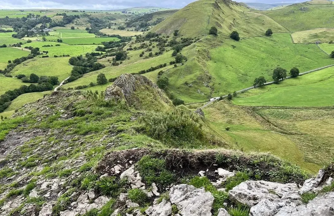
Image Source: AllTrails
Often called the “Dragon’s Back” of the Peak District – how cool is that? – Chrome Hill rises up dramatically to 425 metres (that’s 1,394 feet!). It creates one of the most distinctive and memorable landscapes for any of your Peak District walks. This amazing limestone reef knoll actually formed during the Carboniferous Period, way back when tropical seas covered this whole area. Mind-blowing, right?
Chrome Hill: Choosing Your Walking Distance
Chrome Hill gives you a few good circular route options, so you can pick what suits your hiking mood:
- Short walk from Hollinsclough: This one’s about 4 miles (7 km) and I reckon it’ll take you roughly 2 to 2.5 hours.
- Earl Sterndale circular route: This route is usually around 4.6 to 5.4 miles (7.4-8.7 km) and you should allow about 2 to 3.5 hours.
- Extended circular walk: If you’re feeling more ambitious, there’s a longer 14.3 km route. It’s generally considered a challenging one and will likely take you about 3.5 to 4 hours.
Whichever path you choose, you’ll be doing a fair bit of climbing, with a total ascent of around 423 to 466 metres (that’s 1,387 to 1,528 feet). It’s a decent workout!
Chrome Hill: What You’ll See From the Top
The main highlight here is, without a doubt, the ridge walk along that “Dragon’s Back” formation. It gives you absolutely spectacular panoramic views across the Derbyshire and Staffordshire countryside. As you make your way along, you’ll also come across some fascinating geological features, including a tiny natural arch about halfway along the ridge – a great little photo spot!
Fun fact: Chrome Hill is actually about 65 metres higher than Parkhouse Hill, its neighbour, and together they create such a striking silhouette against the sky. It’s no wonder these two hills form one of the most photographed landscapes in the entire Peak District National Park. This unique scenery definitely makes it one of the best Peak District walks for dramatic views.
I’d say this walk is typically rated as moderate to challenging. There are some technical bits where you’ll need to watch your footing. The climb up has several steep, rocky parts that can get particularly dicey if it’s been raining.
After you’ve crossed a few fields and gates from where you start, you’ll hit a concession path that leads you to the steeper climb. This section has a narrow ridge path – luckily, it’s mostly gravel and pretty well-maintained in most places, but it still needs your full attention.
The way down is just as steep in places, with loose rocks making it a bit more of a challenge. Because of this, I really can’t stress enough how important proper hiking footwear is. It’s probably best to avoid this walk on very wet or windy days too. But, as long as you’re prepared, this amazing Peak District circular walk delivers an absolutely unforgettable experience.
Monsal Trail: A Traffic-Free Trip Through History
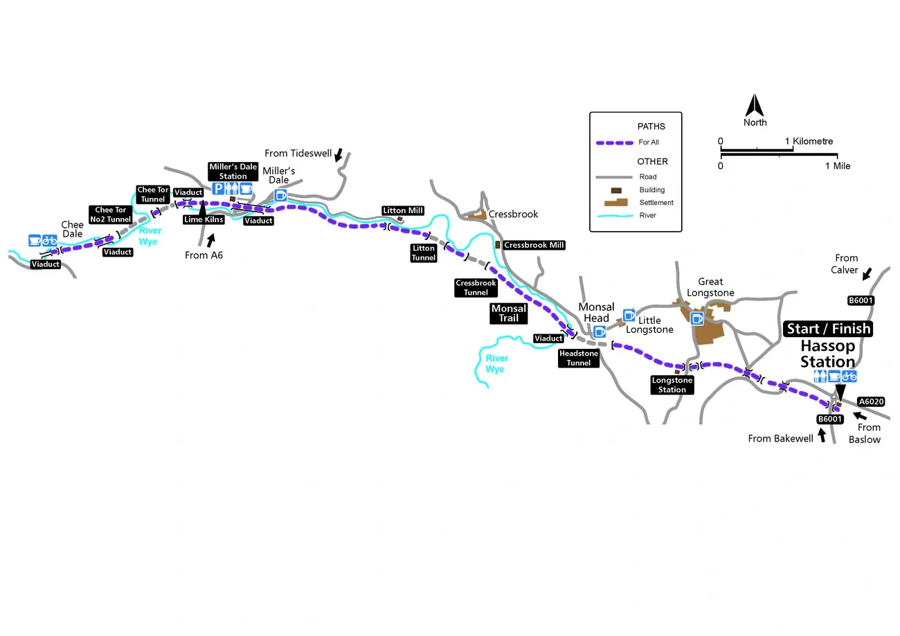
Image Source: Peak District
Once a bustling Victorian railway line, the Monsal Trail now offers a fantastic 8.5 miles of totally traffic-free path. It stretches all the way between Blackwell Mill in Chee Dale and Coombs Road in Bakewell. Trust me, this unique route takes you through some of the most absolutely spectacular limestone dales in the Peak District National Park – it’s a real gem!
Monsal Trail: How Long Does it Take?
The full trail is 8.5 miles if you walk it one way. But there are loads of different access points, so you can easily hop on and off for shorter sections:
- Walking time (one way): Allow about 3 to 4.5 hours for the full length.
- Cycling time (one way): Much quicker! You’ll probably do it in 45 to 70 minutes.
- Running time (one way): For the runners among you, expect it to take about 1 to 2 hours.
If you prefer circular routes, don’t worry! There are loads of lovely walks that branch off from the main trail. You can find easy, family-friendly 2-mile loops starting at Monsal Head, or more challenging 9-mile circuits that even connect up to Buxton. This flexibility makes the Monsal Trail absolutely ideal for tailoring your adventure to how much time and energy you’ve got. It’s one of the most adaptable Peak District walks I know.
Monsal Trail: Must-See Highlights Along the Way
The absolute standout feature has to be the seriously impressive Headstone Viaduct at Monsal Head. Funnily enough, the famous writer John Ruskin really criticised it back in the day, but now it’s celebrated as a proper architectural treasure! As you make your way along the trail, you’ll also pass through:
- Four lit tunnels: Each one is about 400 metres long – they add a bit of fun adventure!
- Historic lime kilns at Miller’s Dale: These used to burn limestone at incredibly high temperatures (over 900°C!) for industry and farming.
- Former cotton mills at Cressbrook and Litton: The one at Litton sadly became notorious for its harsh treatment of child labourers back in the day.
But it’s not just about the industrial history. The trail offers loads of chances to spot wildlife, especially as it cuts through beautiful limestone gorges that were formed over 350 million years ago! Maybe keep an eye out for creatures you wouldn’t see on a typical city break exploring free museums in London?
Monsal Trail: Is it Easy Terrain?
Yes, mostly! Because it follows the path of an old railway line, the Monsal Trail is pretty much flat all the way along, making it one of the most accessible Peak District walks around. The gentle gradients make it perfect for:
- Wheelchair users: There are accessible ramps at Bakewell, Hassop, Great Longstone, and Miller’s Dale stations.
- Families with young children and pushchairs: It’s a smooth surface most of the way.
- Casual walkers: If you’re just looking for a lovely flat walk without steep hills, this is ideal.
One thing to remember – the tunnels stay lit during daylight hours, but the lights usually switch off around 4:30 pm in the winter months. So, if you’re planning a late afternoon walk then, definitely bring a torch! Overall, this is a fantastic option if you want to enjoy the beauty of Peak District circular walks without tackling any strenuous climbs.
The Roaches: Staffordshire’s Dramatic Gritstone Ridge
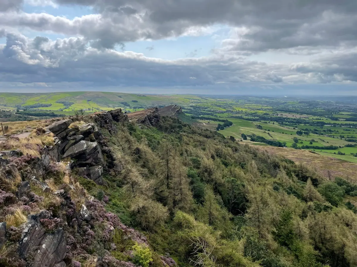
Image Source: Peak District
The Roaches is this absolutely spectacular gritstone escarpment that creates one of the most dramatic landscapes in the whole Peak District National Park. You’ll find it near Leek in Staffordshire. This impressive rocky ridge stretches for about 2 miles and is super popular with both hikers and rock climbers.
The Roaches: Which Walk is Right For You?
The Roaches is brilliant because it offers walks to suit pretty much everyone, whatever your fitness level:
- Standard circular walk: This is a lovely 6.6km (4.1 miles) route that usually takes between 1.5 and 2 hours. A great all-rounder!
- Short family-friendly option: If you’ve got little ones or just fancy a shorter stroll, there’s a 2-mile (3.2km) circuit. I’d allow about 2 hours for this one, maybe even 3-4 hours if the kids (or you!) want plenty of time to explore the rocks.
- Extended adventure to Lud’s Church: Fancy making a bigger day of it? You can extend the walk to include the mysterious Lud’s Church chasm – this makes it about 6.75 miles and will take significantly longer.
This adaptability really makes The Roaches one of the most accessible yet rewarding Peak District walks you can choose.
The Roaches: Views, Legends, and Wildlife
Okay, the main draw here is definitely the panoramic views from the top of the ridge. On a clear day, you can see for absolutely miles – right across East Cheshire, the Staffordshire Dales, and sometimes even into Wales! The highest point has a trig point standing at an impressive 505m, making it the 27th highest peak in the Peak District.
As you walk along, keep an eye out for Doxey Pool. It’s this mysterious little body of water that legend says is home to a naughty mermaid called Jenny Greenteeth, who apparently lures travellers to their doom! Spooky! You might notice the area feels really special for wildlife too – it’s actually a Site of Special Scientific Interest looked after by the Staffordshire Wildlife Trust. Exploring unique spots like this beats staying indoors, maybe even more fun than tackling some 15 Best Escape Rooms in London!
The Roaches: What’s the Path Like?
I’d generally class this walk as a moderate challenge. The terrain changes quite a bit along the way. The start involves a steep climb over rough, rocky ground. But once you’re up on the ridge, the path flattens out quite a bit into a dirt trail with amazing rock formations alongside – perfect if you fancy a bit of easy scrambling (climbing over rocks).
Of course, you’ll need proper footwear, as the paths can get slippery when wet. The route is very exposed to the wind and weather, and there are some pretty sheer drops along the way, so picking a calm day will definitely make for a more comfortable walk.
The good news is the gritstone rocks provide excellent grip when they’re dry. However, some sections can become quite treacherous after rain. My favourite time to visit? Summer, when the heather covers the landscape in stunning purple blooms – it’s just beautiful! It’s easily one of the best Peak District walks for that rugged, wild feel.
Curbar Edge: Sunset Views and Wildlife Wonders
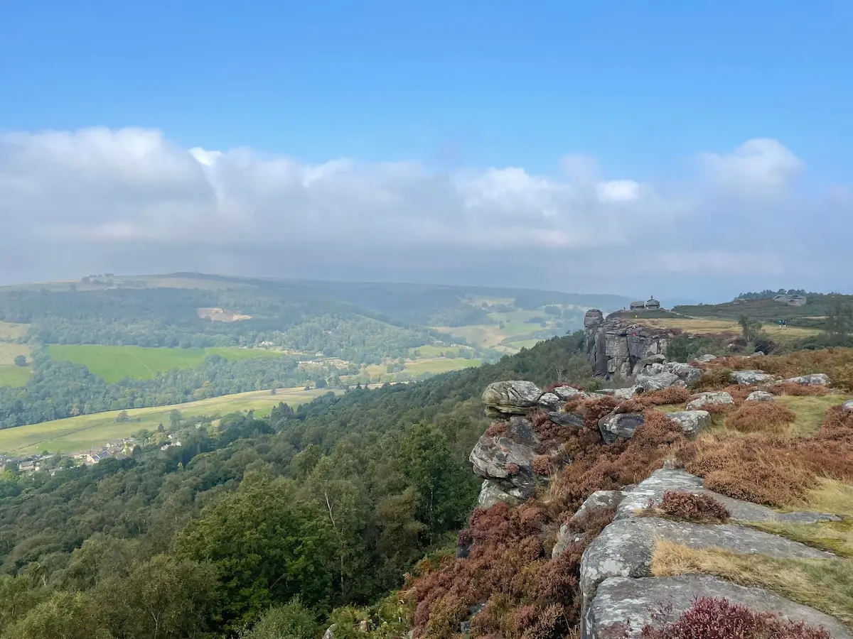
Image Source: PeakDistrict.org
Among the Peak District’s dramatic gritstone edges, Curbar Edge stretches impressively along the eastern side of the beautiful Derwent Valley. Let me tell you, it offers absolutely spectacular panoramic views – photographers especially love it here around sunset!
Curbar Edge: Your Walk Length Options
Curbar Edge gives you a few different circular routes, so you can pick one that suits your fitness level:
- Standard loop: This popular route is about 6 miles (9.6 km) and usually takes me around 2.5 to 3 hours.
- Extended circular: If you fancy a bit more, there’s a 9.4 km (5.8 miles) loop. Allow about 3.5 hours for this if you’re walking solo, but maybe up to 5 hours if you’ve got kids exploring with you.
- Shorter alternative: Need something a bit quicker? There’s a 4.2-mile (6.7 km) option that takes roughly 3 hours.
My top tip? Whichever route you choose, try and start early. The parking at Curbar Gap fills up really quickly, especially during busy times. This makes Curbar Edge one of the more popular Peak District circular walks, so an early start is definitely worth it!
Curbar Edge: What Makes It Special?
The main reason people flock here is definitely those amazing views across the Derwent Valley. The path runs right alongside dramatic gritstone outcrops, which are also really popular with climbers – you might see some tackling the sheer rocks! But unlike some other Peak District walks, this route offers some unique wildlife spotting opportunities too. Keep your eyes peeled for:
- Red deer: You might spot these magnificent creatures on Big Moor. The best time to see them is during the rutting season (autumn), and bringing binoculars really helps as they can be quite well camouflaged!
- Adders: On sunny spring and summer days, you might be lucky enough to see an adder basking in the sun. They’re the UK’s only venomous snake, so treat them with respect, but they’ll usually slither away when you approach.
- Heather: Visit after mid-August, and you’ll see the moorland transformed into vibrant shades of purple when the heather is in full bloom. It’s stunning!
You’ll also find bits of history dotted around, like ancient stone circles that become visible as the path emerges from woodland areas. It adds a lovely touch of culture to the natural beauty.
Curbar Edge: Understanding the Terrain
This walk is generally rated as moderate. It mixes mostly flat sections along the edge with some parts that are steep, stony, and narrow. The path starts by climbing uphill from the car park before reaching those rewarding viewpoints at around 365m.
You’ll definitely need proper footwear, as things can get slippery and tricky after rain. Plus, you’re very exposed to the weather along the edges, so bringing extra layers is always a smart move, even on a sunny day. While kids often love this walk (especially clambering on the rocks!), the exposed edges mean you need to keep a close eye on them.
Unlike some of the really gentle walks in the Peak District National Park, Curbar Edge does have some tricky sections, especially coming down from the escarpment. But for most reasonably fit walkers, it’s perfectly manageable and offers magnificent views without needing extreme effort.
Padley Gorge: A Magical Woodland Wander
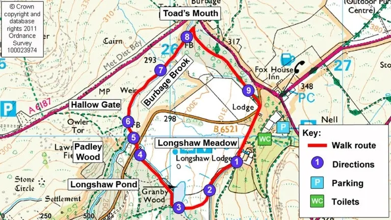
Image Source: National Trust
Nestled right in the heart of the Peak District, Padley Gorge is like stepping into an enchanted woodland. Imagine tumbling streams, gorgeous moss-covered boulders, and that ancient forest feel. This beautiful spot is actually an ancient oak woodland and a designated Site of Special Scientific Interest (SSSI). It’s one of the best examples I’ve seen of the kind of oak-birch woodland that used to cover much of the Peak District.
Padley Gorge: How Long Will Your Woodland Walk Be?
Padley Gorge has a few lovely circular route options, so you can pick what suits you:
- Short family-friendly circuit: This one is about 2.7km (1.7 miles). I’d allow around 3 hours if you’re stopping for paddles and exploring with kids!
- Standard circular walk: This is a popular 3.6-mile (5.9km) loop, which usually takes me about 2 hours.
- Extended circular route: If you want to stretch your legs a bit more, there are options ranging from 5.3km to 9.3km. These can take anywhere from 1.5 to 2.75 hours if you’re a fairly active hiker.
Honestly, how long you spend here really depends on your pace and how much you want to explore. What might be a quick one-hour walk for adults often turns into a lovely three-hour adventure for families. The kids (and let’s be honest, the adults too!) just can’t resist paddling in the shallow bits of Burbage Brook, especially on a warm day.
Padley Gorge: What Enchanting Sights Await?
The main draw of Padley Gorge is definitely its absolutely enchanting scenery. You’ve got Burbage Brook happily cascading over rocks, creating a series of charming little waterfalls all through the gorge. The woodland itself is bursting with life, making it a real haven if you love spotting wildlife:
- Rare pied flycatchers actually breed here! It’s one of the few places in the UK where they thrive, so keep an eye out.
- Birdwatchers might also spot woodpeckers, dippers, and loads of other lovely species.
- The ancient, gnarled trees covered in moss create such a magical atmosphere, no matter what time of year you visit. It’s like something out of a fairy tale!
The gorge looks different throughout the year, which is part of its charm. You’ll find bright rhododendrons blooming in May and June, and then the most stunning autumn colours around October. It really does have year-round appeal, making it one of the most picturesque Peak District walks.
Padley Gorge: Is the Path Easy to Follow?
Compared to some of the more rugged Peak District walks, this one is relatively easy, but the terrain does have a few little challenges. The main path is mostly flat with some gentle ups and downs. However, some sections can get quite muddy, especially after it’s been raining. Luckily, there are usually rocks scattered about in the muddy bits, which help you navigate around the worst of it.
You’ll find some steeper sections along the trail, and these can get slippery when they’re wet, so I’d definitely recommend wearing suitable footwear. The National Trust has done a great job maintaining the paths, making this one of the more approachable Peak District circular walks.
Just a little note for families: the first half of the walk through the gorge itself isn’t really suitable for pushchairs. But, once you reach the connecting Longshaw Estate, the paths there are much better for buggies. Exploring this beautiful area is a world away from city life, perhaps even more refreshing than discovering one of those 17 Best Parks in London for Families & Nature Lovers.
Ladybower Reservoir: Dambusters History and Sunken Villages
Image Source: Peak District
Spanning an impressive 520 acres, Ladybower Reservoir creates this really distinctive Y-shaped dam. It’s filled by the River Ashop and the River Derwent and holds a mind-boggling 464 billion litres of water! This magnificent body of water offers some of the most accessible yet incredibly scenic Peak District walks, perfect for visitors of all abilities.
Ladybower Reservoir: Walk Durations for Everyone
There are several lovely circular routes here, so you can pick one that suits your fitness and how much time you’ve got:
- Standard circular walk: This one is about 9.2km (that’s 5.7 miles) and usually takes me around 2 to 2.5 hours. But honestly, I’d recommend allowing a good 2 to 3 hours so you’ve got plenty of time for taking photos and maybe stopping for a cuppa and a snack!
- Shorter family option: If you’re with little ones or just fancy a quicker stroll, there’s a lovely 5-mile route that’ll take you about 1 to 2 hours.
- Extended reservoir loop: For the more experienced hikers among you, there’s a longer 13.2-mile loop. You’ll need about 6.5 hours for this bigger adventure.
Which one you choose really depends on your day. In my experience, that standard circular route is a great balance – it’s easy to get around and you see so much beautiful scenery.
Ladybower Reservoir: What You’ll See on Your Walk
Aside from the absolutely beautiful tranquil waters, this walk showcases the magnificent Derwent Dam wall. It’s a really historic spot because it’s where the brave 617 Squadron (you might know them as the Dambusters!) practised for their famous raids during World War II. As you wander along, you’ll also get to enjoy:
- Breathtaking views: Look out across the deep valley waters to the surrounding woodlands and rolling moorland hills. It’s stunning!
- The Ashopton Viaduct: This impressive structure spans right across the water and is a real landmark.
- Sunken villages: Here’s a fascinating bit! In times of low water, you might even catch a glimpse of the old villages of Derwent and Ashopton, which were flooded when the dam was built between 1935 and 1943. Only two buildings, the Lodge and the schoolroom, are still visible today. Imagine the history hidden beneath the water!
Ladybower Reservoir: Is it an Easy Walk?
Yes, this one is typically rated as easy. The paths are well-maintained and follow the edge of the reservoir pretty much the whole way. When you look at the climb:
- Total ascent: It’s just 175 to 247 metres, which is pretty gentle.
- Gentle undulations: You won’t find any super steep climbs here, just gentle slopes.
- Accessible paths: The paths are well-surfaced, making them great for pushchairs and wheelchairs.
The route takes you through a lovely mix of open views and wooded sections. This makes it brilliant for families with young children, or anyone who is perhaps a less experienced walker but still wants to enjoy some fantastic Peak District walks. As always, I’d still recommend good footwear, as some bits can get a bit muddy if it’s been raining.
Baslow Edge: Heather Views and Highland Cows
Image Source: Peak District Walks
Sitting pretty near the lovely village of Baslow, this striking gritstone escarpment offers some of the most easily accessible Peak District walks that still reward you with breathtaking views over the countryside. As the most southerly edge in the Peak District, Baslow Edge gives you that perfect balance of stunning scenery without the massive crowds you sometimes find at its neighbours.
Baslow Edge: Finding Your Ideal Walk Length
There are several route options here, so you can pick one that fits your plans:
- Short circular walk: This is a nice and concise 2.7km (1.7 miles). It usually takes me about an hour if I’m striding out, but allow up to 2 hours if you fancy stopping to admire the views (which you will!).
- Medium route: This one is about 3.9 miles (6.3 km) and you’ll probably need around 1.5 to 2.5 hours to complete it.
- Extended circular: Feeling like a longer wander? There’s a 7.2-mile (11.6 km) option that takes about 3 to 4 hours.
And if you’re feeling really adventurous, you can even tackle the bigger 13km Baslow-Curbar-Froggatt circuit, which usually takes just over 4 hours.
Baslow Edge: What Will You See?
Since Baslow Edge sits at 315 metres (1,033 feet) above sea level, the views on a clear day are seriously impressive. From the edge, you can easily spot:
- Kinder Plateau: Yep, you can see the highest point in the Peak District from here!
- Charming villages: Look down into the valley below and you’ll see picturesque little villages nestled in the landscape.
- Chatsworth House: Keep an eye out in the distance for this famous stately home.
But it’s not just about the long-distance views! Visitors often get a lovely surprise encountering the very friendly Highland cattle that frequently graze near the path. I absolutely adore seeing them! The whole area transforms beautifully through the seasons too, especially in late August and early September when the purple heather carpets the moorland. It’s just gorgeous and makes for fantastic Peak District walks during late summer.
Baslow Edge: Is it a Difficult Walk?
This walk is generally considered moderately challenging. The path mixes different surfaces – you’ll walk on sandy bits, rocky bits, some tarmac, and dirt sections. Depending on which route you choose, the total climb ranges from a gentle 55 metres to a more noticeable 320 metres, so it’s pretty accessible for most fitness levels.
One thing to be aware of is that some paths can split off in different directions, especially as you come off the edge itself. I’d recommend keeping a map handy just in case. I quite like how the route often takes you both below and above the edge – it gives you really different perspectives and makes the walk interesting the whole way through! Making sure you’re prepared for different paths is always wise, a bit like checking when do the clocks change? so you don’t miss out on daylight!
Stanage Edge: Pride & Prejudice Views and Gritstone Wonders
Image Source: PeakDistrict.org
Stretching for an impressive 4 miles along the Eastern Peak District, Stanage Edge is often called the king of Derbyshire’s gritstone escarpments. It reaches its highest point at High Neb, standing tall at 458 metres above sea level. This spectacular cliff face is incredibly popular, attracting both casual walkers looking for breathtaking views and serious rock climbers ready to tackle its 1,500+ recorded routes!
Stanage Edge: Choosing Your Route Length
The beauty of Stanage Edge is that you can easily tailor your walk:
- Standard circular route: This is about 7km (4.9 miles) and usually takes me around 2 to 3 hours to complete.
- Extended circuit from Hathersage: If you start from the village of Hathersage, you can make it an 8-9 mile walk, which takes about 2-3 hours if you keep up a decent pace.
- Short walk from Hooks Carr Car Park: Fancy just a quick blast up to the top? You can do that too! From the nearest car parks, you can spend anything from just 30 minutes to a whole day exploring along the ridge. It’s totally up to you how far you wander!
The climb up from most car parks only takes about 10-15 minutes, but trust me, you’ll likely spend much longer just soaking in the views and exploring the ridge itself. If it’s your first visit, I’d suggest allowing at least 2.5 hours to really appreciate this iconic landscape. It’s one of those Peak District walks you don’t want to rush.
Stanage Edge: What Makes It Famous?
Beyond those incredible panoramic views across the Dark Peak moorlands and the lovely Hope Valley, Stanage Edge has a few other claims to fame:
- Pride & Prejudice! Yes, this is where Keira Knightley stood looking all windswept and thoughtful in the famous film adaptation. You can stand on the very same rocks! How cool is that? It draws loads of film fans here.
- Abandoned Millstones: As you walk, you’ll spot old millstones dotted across the landscape. These are fascinating relics from when this area had a thriving millstone industry, which started to decline back in the 1860s. They’ve become real symbols of the Peak District National Park.
Stanage Edge: The Terrain Underfoot
Even though getting to the ridge from the nearby car parks is relatively easy, there are parts you need to be mindful of. The first climb up can be steep, and the paths can definitely get slippery and muddy, especially after rain.
But the good news is, once you’re up on the ridge, the path becomes much flatter, making it easier to walk along and enjoy the views. Still, the edge itself has uneven rocky surfaces and some pretty sheer drops, so you absolutely need proper footwear and should take care where you tread. Taking your time and enjoying the view is much better than rushing – maybe it’s even a good spot to reflect, unlike the hustle needed for the Best Shopping in London?
My tip for photographers: the light is often most magical in the evening as the sun starts to go down, casting a beautiful warm glow on the rocks. Just be aware that it can get quite windy and chilly along this exposed edge, even on a warm day in the valley. And keep an eye out for wildlife – you might even spot a rare Ring Ouzel if you’re lucky! This is definitely one of the most rewarding Peak District walks for stunning scenery and a bit of history.
Dovedale Stepping Stones: Picture-Perfect River Crossing
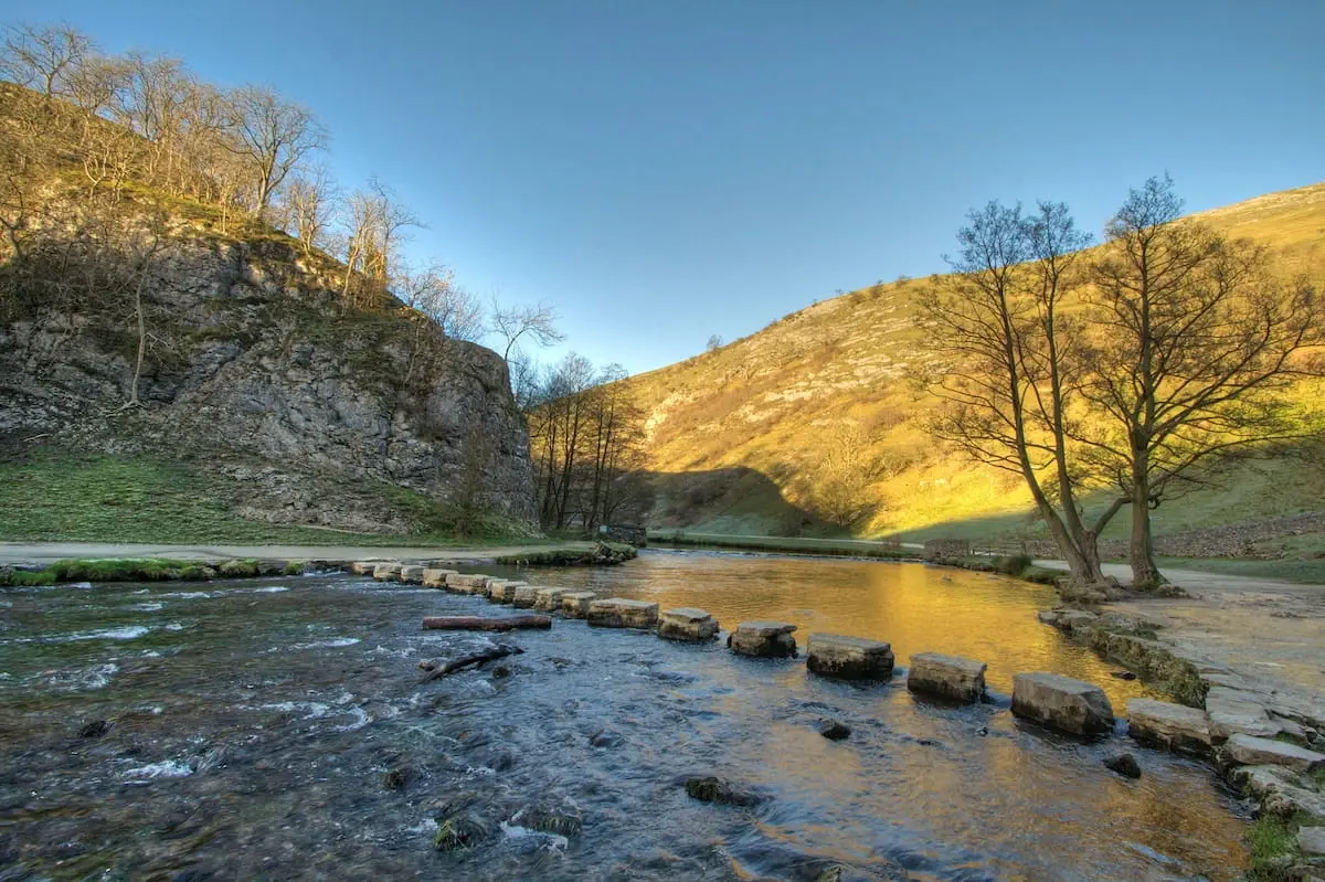
Image Source: Peak District
Put in place way back in the middle of the 19th century, the iconic Dovedale Stepping Stones have been drawing visitors for absolutely ages! They are easily one of the most popular spots for quintessential Peak District walks. These limestone crossings create one of the most photographed scenes in the entire national park, offering a bit of fun adventure and loads of picture-perfect moments.
Dovedale Stepping Stones: Walk Options Galore
The great thing about Dovedale is its flexibility. You’ve got multiple route options depending on how far you want to go:
- Short walk to stepping stones: Fancy just seeing the main attraction? It’s only about half a mile (roughly a 10-minute stroll) from the main car park. Super easy!
- Stepping stones circuit: Just want to cross the stones and loop back? That’s about a 1-mile walk and takes around 20 minutes.
- Dovedale-Thorpe Cloud circular: Combine the stones with a climb up the nearby hill for amazing views! This route is 1.5 miles and you’ll probably need about 1 hour 30 minutes.
- Extended Dovedale-Milldale route: Want a longer riverside walk? You can continue along the dale to Milldale. This makes it about 5.5-6 miles (8.7-9.7km) and takes around 2-3 hours.
Just so you know, this spot is incredibly popular, especially the short walk to the stones. My advice? Get there early, particularly during peak season or on sunny weekends, as it can get exceptionally busy!
Dovedale Stepping Stones: Highlights of the Dale
Besides the fun of hopping across the beautiful River Dove on those famous stones, take a closer look at the stones themselves – you can often spot fascinating fossils embedded right in the limestone! Once you’re safely across, the path leads you past several other interesting features:
First up, you’ll see Lover’s Leap – a rocky outcrop named after a local legend about a heartbroken woman who jumped from the top but was supposedly saved by the bushes below! A bit dramatic! If you choose one of the longer routes, the path continues past Reynard’s Cave and eventually reaches Dove Holes cave.
The whole area, with its limestone ravines and crystal-clear waters, is just perfect for finding a nice spot for a picnic. It makes this area ideal for families wanting a relaxing day out and one of the best Peak District walks for a gentle introduction to the park’s beauty.
Dovedale Stepping Stones: Mind Your Step!
Okay, while this walk is super popular, it does have a few challenges to be aware of. The route includes fields and slopes that can definitely get muddy and slippery, especially after rain.
And sometimes, if there’s been really heavy rain, the River Dove can flood, covering the stepping stones completely! If that happens, don’t worry – there’s usually a footbridge nearby you can use instead (though always check the conditions before setting off).
The National Trust recommends wearing suitable footwear because the paths can be quite uneven in places. Just something to keep in mind for a comfortable walk! It’s a bit different from navigating the smooth pavements when you’re enjoying the best shopping in London!
One last thing for families: while kids absolutely love this walk (especially the stones!), the path isn’t really suitable for pushchairs or prams because of the uneven terrain and slopes.
Thorpe Cloud: A Short Climb to Stunning Dovedale Views
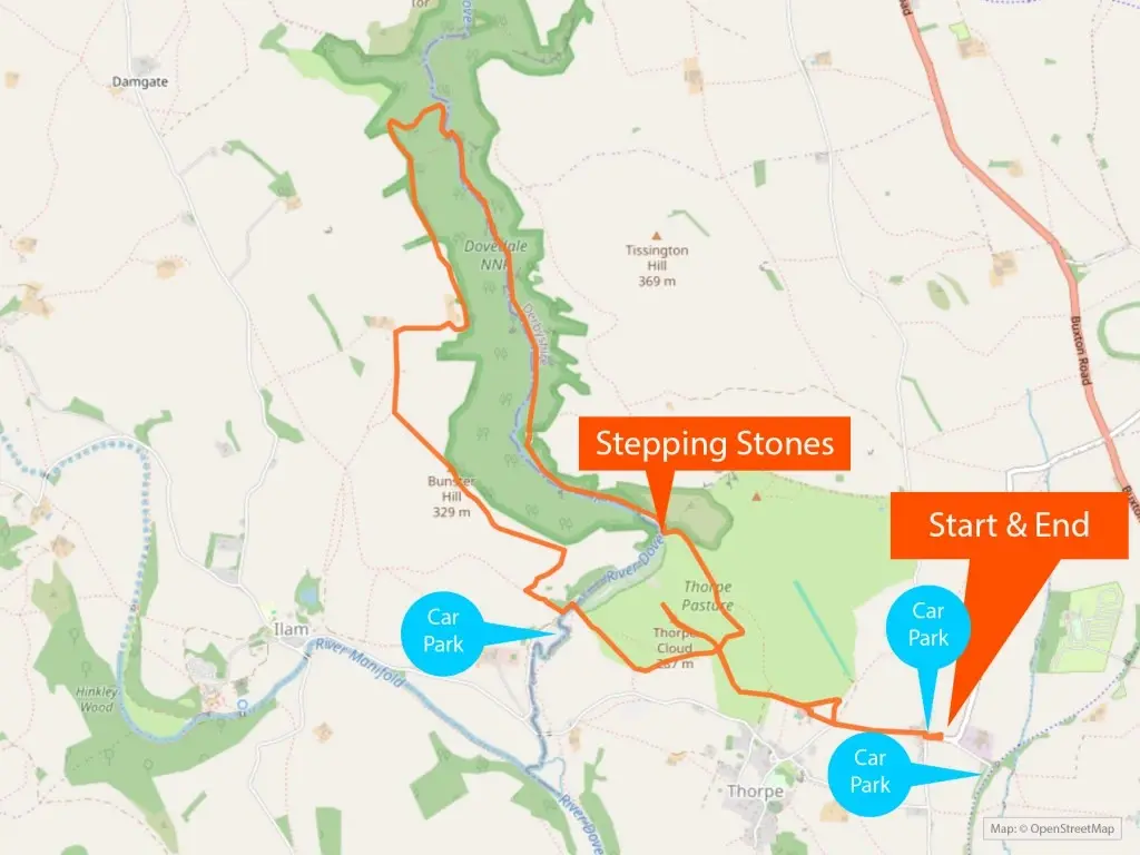
Image Source: Ella McKendrick
Rising dramatically from the Dovedale valley almost like a limestone island, Thorpe Cloud stands at 287m above sea level. Its distinctive cone shape makes it one of the most easily recognisable landmarks on many Peak District walks. This isolated limestone hill attracts loads of visitors who are looking for stunning panoramic views without having to put in hours and hours of hiking effort.
Thorpe Cloud: Quick Walks, Big Rewards
There are a few different ways to tackle Thorpe Cloud, depending on how much time you have:
- Short direct summit hike: Starting from the Dovedale car park, this is about 2 miles (3.2 km) and usually takes me around 1 to 1.5 hours. It’s short and sweet!
- Thorpe Cloud circular walk: There’s a slightly shorter loop of 2.9 km that you can probably do in about an hour.
- Extended circular route: If you want to combine it with a bit more of the surrounding area, there’s a 6.3 km (3.9 miles) route that takes roughly 2 hours and 5 minutes.
Hikers I’ve chatted with often say the actual climb to the summit is surprisingly quick – often just 20 to 30 minutes from the bottom! This efficiency makes it one of the best walks in the Peak District if you want magnificent views without committing to a really long hike.
Thorpe Cloud: What You’ll See From the Summit
Once you reach the top, you are seriously rewarded with outstanding panoramic views across Dovedale. You can see the majestic shape of Bunster Hill, the impressive Ilam Hall in the distance, and the quaint Lin Dale valley. The very top of Thorpe Cloud is like a long, flat walkway made of limestone peeking through the grassy surface, dotted with lovely tufts of moss.
Here’s a little secret – if you carefully wander along the ridge towards the far end, you get an extra special treat: a bird’s-eye view right down onto the famous Dovedale Stepping Stones! You can watch the tiny figures of people making their way across. What’s also amazing is thinking about the geology here – the limestone hill was formed about 350 million years ago from the fossilised remains of sea creatures when this area was a shallow sea! Mind-boggling stuff to ponder during your Peak District walks.
Thorpe Cloud: Is the Climb Difficult?
This walk is generally considered moderately challenging. It starts off with gradual paths, but it definitely gets steeper as you get closer to the top. The final section involves a bit of a scramble over rocky ground, which can be more tricky if it’s been raining.
Honestly, I can’t recommend proper footwear enough for this one, especially good walking boots with ankle support. The path can get really quite slippery after rain. While it might look a bit intimidating when you first see it, the climb is actually very doable for most visitors – I’ve seen plenty of families with young children enjoying the challenge and reaching the summit.
Just like Dovedale, Thorpe Cloud is super popular. To avoid the biggest crowds, especially around lunchtime, try to arrive early. All in all, this short but rewarding climb offers amazing value for the effort involved, giving you those breathtaking views that make Peak District walks so special.
Grindslow Knoll: A Challenging Scramble to the Top
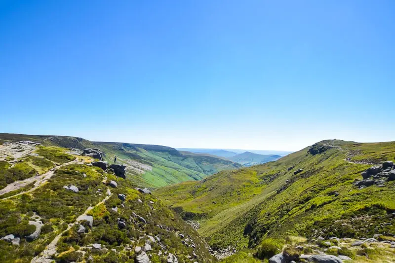
Image Source: Peak District Walks
Sitting majestically at 601 metres (that’s 1,972 feet!) above sea level, Grindslow Knoll offers one of the most truly rewarding Peak District walks – but only if you’re up for tackling its challenging terrain! This lofty summit is perched on one of Kinder Scout’s central southern ‘limbs’, giving it this amazing elevated and isolated position that delivers absolutely exceptional panoramic views.
Grindslow Knoll: How Far Will You Walk?
The routes up to Grindslow Knoll vary a bit in length, catering to different hiking preferences:
- Short challenging circular: This route is about 4 miles (6.5 km) and typically takes around 2 to 3 hours. Don’t let the ‘short’ fool you – it packs a punch!
- Standard loop trail: This one is 6.2 km and you should probably allow about 2 hours and 38 minutes to complete it.
- Extended circuit via Ringing Roger: Fancy a longer route? This circuit is 5.5 miles (9 km) and will likely take you between 2.5 and 3.5 hours.
In my experience, how long it actually takes really depends on how comfortable you are with scrambling. Even on the shorter routes, loads of hikers say they take around 4 hours because the stunning views just make you want to stop and stare constantly!
Grindslow Knoll: Summit Views Worth the Climb
Reaching the summit rewards all your effort with a large stone cairn marking the top, and absolutely spectacular views stretching out in every direction. On a clear day, you’ll be treated to sweeping vistas over:
- The beautiful vale of Edale and the iconic Great Ridge.
- Mam Tor and Lose Hill off to the south-west.
- Across the wild Kinder Scout plateau towards Crowden Brook and the rocky Woolpacks.
These amazing viewpoints give you the perfect chance to appreciate the rugged beauty of the Dark Peak landscape. It totally justifies why this walk is considered one of the best Peak District walks, despite the effort involved.
Grindslow Knoll: Tackling the Tough Terrain
Right, let’s be honest – this route definitely falls into the challenging category! The path starting from Edale climbs gradually towards Grindsbrook Clough, but then it hits some genuinely steep sections.
The final push to the top involves a pretty difficult scramble. Lots of people describe it as “a hard scramble on the way up,” and you’ll definitely need to be confident clambering over wet rocks and using your hands to help you climb.
Just be warned, after rain, some areas can become seriously treacherous. I’ve heard reports of “waist-deep mud” in some of the marshy sections! Proper hiking boots are absolutely non-negotiable for this walk, as loose rocks add another layer of difficulty on both the way up and the way down. But, if you come properly prepared, this Peak District circular walk delivers an authentic, exhilarating upland hiking experience that really showcases the raw beauty of the national park. It’s a tough one, but oh-so-worth-it! Maybe plan a relaxing evening afterwards, perhaps avoiding tricky tasks like figuring out how to improve your credit score and just putting your feet up!
The Trinnacles: Saddleworth Moor’s Dramatic Stacks
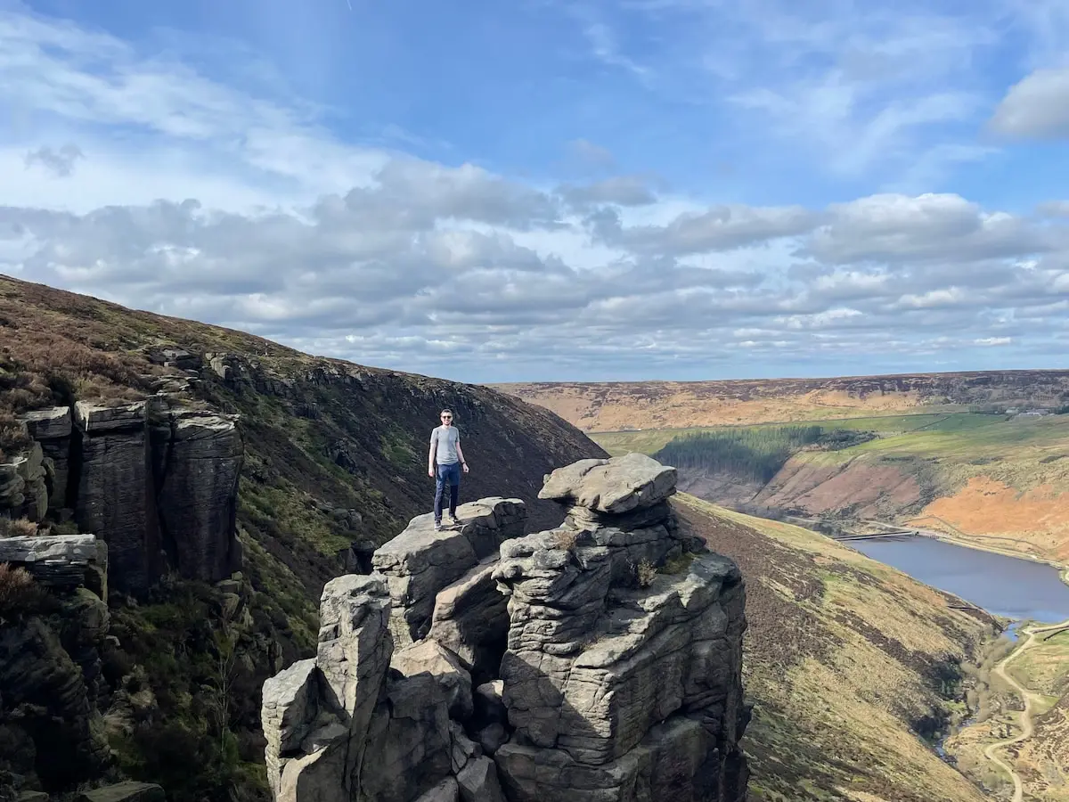
Image Source: Peak District
Hidden away in the wild beauty of Saddleworth Moor, you’ll find The Trinnacles – this really distinctive three-pronged gritstone stack. It’s become a real magnet for adventurous hikers looking for dramatic photo opportunities on their Peak District walks. This mysterious rock formation, carved out by the last Ice Age, stands about 450-460m (that’s roughly 1,500ft) above sea level and offers absolutely extraordinary panoramic views that definitely reward the effort it takes to get there.
The Trinnacles: Walk Durations and Considerations
The Trinnacle Trail offers a few different circular route options:
- Standard circular walk: This is usually around 7-8km (4.5-5 miles) and takes about 2 to 3 hours.
- Extended loop: Fancy a longer trek? There are loops ranging from 9.5km up to 13.5km (5.9-8.4 miles), which will probably take you between 3 and 4 hours.
- Shorter route from Binn Green Car Park: You can also start from Binn Green, making it about a 6km (3.7 miles) walk. I’d still allow at least 3 hours for this one, though.
Why the variation? Well, your timing here really depends on the weather, how many photos you stop to take (and trust me, you’ll take loads!), and sometimes even how long you have to queue at the rock formation itself if lots of people are waiting for that iconic photo.
The Trinnacles: Highlights of the Hike
The walk usually starts from Dovestone Reservoir on relatively flat ground before you begin the climb. As you get higher, you’ll pass some really impressive rock formations along the ridge before you finally reach the famous three-pronged monolith itself. The Trinnacles stack stands about 10 metres (33 feet) tall and makes a natural platform offering truly breathtaking views across Greenfield Reservoir and the wild moorland all around. It’s a proper ‘wow’ moment on your Peak District walk.
The Trinnacles: Understanding the Terrain and Risks
This trail is generally rated as moderate, but let me tell you, it definitely becomes challenging when the weather turns nasty. The route involves:
- A steep climb to get up onto Saddleworth Moor – some bits might need you to use your hands for balance.
- A tricky scramble up Birchen Clough waterfall. Be extra careful here, as the rocks get dangerously slippery after rain.
- Narrow paths with some severe drops alongside, so careful navigation is crucial.
Now, a really important warning: While you can climb onto the actual Trinnacle formation, it carries significant risk. There’s a sheer drop on the other side. Both the Peak District National Authority and the brilliant Oldham Mountain Rescue Team strongly advise against climbing onto the rock, especially if it’s wet or windy. It’s just not worth the risk for a photo! Experiencing the view from the base is amazing enough. Maybe think of it like admiring the view from one of London’s safest Rooftop Bars London rather than trying something dangerous!
Proper walking boots are absolutely essential for this hike, whenever you decide to visit.
Bamford Edge: That Famous Instagram Stone & Reservoir Views
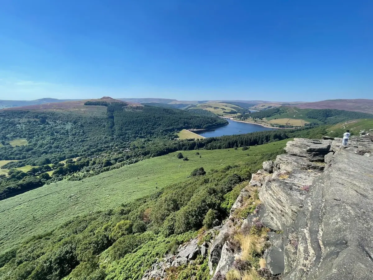
Image Source: Peak District
Perched right along the eastern edge of the lovely Hope Valley, Bamford Edge rewards hikers with absolutely spectacular panoramic views. Honestly, it’s become one of the most photographed spots in all the Peak District walks I’ve done! This dramatic gritstone escarpment offers completely unparalleled vistas across Ladybower Reservoir and the gorgeous surrounding landscapes.
Bamford Edge: How Long is the Walk?
Bamford Edge gives you a few different circular routes to choose from, depending on how much time you have:
- Short circular walk: This is a nice concise 1.9 miles (3.1 km) and usually takes me about 1 to 1.5 hours. Perfect for a quick blast of fresh air and amazing views!
- Moderate loop: This popular option is 5.8 km (3.6 miles). I’d suggest allowing 2 to 3 hours for this one, mainly because you’ll be stopping for photos all the time!
- Extended adventure: If you want to make more of a day of it, there’s a longer 9.3-mile (14.29 km) route that takes around 4 to 5 hours.
Honestly, even if you choose a shorter walk, give yourself extra time. The views that unfold at every single turn are just too good to rush past!
Bamford Edge: Highlights and Photo Spots
The number one reason to come here is undoubtedly those breathtaking views looking down over Ladybower Reservoir, nestled beautifully between the hills. On a clear day, you can see for miles, spotting landmarks like:
- Win Hill and Parkin Clough
- Lose Hill and The Great Ridge
- Crook Hill
- Those quirky, distinctive “plugholes” in Ladybower Reservoir
But it’s not just about the incredible vistas! Keep an eye out for bits of history too, like the old sighting towers that were used when the Rivelin Tunnel was being built, and an abandoned millstone left over from a former quarry. And, of course, there’s that Instagram-famous overhanging stone! It’s probably one of the most popular photo spots in the entire Peak District – you’ll definitely want to grab a picture there (safely, of course!).
Bamford Edge: Terrain and Difficulty Level
This walk is generally rated as moderate. It starts with a pretty steep uphill hike to get you up onto the edge, but thankfully it levels out quite nicely once you’re up there. The total climb is usually between 217 and 235 metres, depending on where you start.
Most of the effort is right at the beginning, which I quite like – you get the hard work done early! Afterwards, the path runs relatively flat along the edge, meaning you can enjoy those magnificent views without too much more heavy breathing. As always with these Peak District walks, decent footwear is a must, as some sections can get slippery after rain. It’s a fantastic walk that delivers huge views for a manageable amount of effort. It’s the kind of view that makes you appreciate getting outdoors, perhaps even more than enjoying the convenience of the best air fryers at home!
Conclusion: Your Peak District Adventure Awaits!
Wow, what an adventure we’ve been on just reading about these incredible Peak District walks! From the family-friendly paths of the Monsal Trail to the heart-pumping scrambles up Grindslow Knoll, it’s crystal clear that this stunning national park truly offers walking experiences for absolutely everyone. Whether you’re after a gentle stroll or a proper mountain challenge, the diverse landscapes here cater for all.
Throughout my own explorations, the sheer variety never fails to blow my mind. One day I might be wandering through the magical, mossy woodland streams of Padley Gorge, and the next I could be standing triumphantly on Mam Tor’s windy summit, gazing out at those epic views. That contrast is what makes walks in the Peak District so special.
Now, remember that the weather here can change in a blink of an eye! So, no matter which of these amazing Peak District walks you choose, please make sure you’re properly prepared. Good, sturdy walking boots are a must, along with weather-appropriate clothing (waterproofs are always a good shout in the UK!) and navigation tools like a map and compass or a reliable GPS. Trust me, being prepared makes the difference between a brilliant day out and a bit of a soggy struggle!
These fifteen trails I’ve shared really showcase the rich history and stunning natural beauty of the area – from prehistoric hillforts and Roman roads (okay, maybe not Roman roads exactly, but ancient tracks!) to Victorian viaducts and mysterious rock formations. Every single one of these Peak District circular walks and routes tells its own unique story.
Whether you visit when the heather turns the moors purple in late summer or during the crisp, clear days of winter, the Peak District’s beauty is simply breathtaking all year round. Think of these fifteen best Peak District walks as just the beginning. There are countless more paths, peaks, and hidden valleys waiting to be discovered. So, lace up your boots, grab your map, and get ready to explore – your next unforgettable Peak District adventure is calling! Happy hiking!
FAQs: Your Peak District Walks Questions Answered
Got a few more questions buzzing around about planning your Peak District walks? No worries, I’ve put together answers to some common ones!
Q1. What is the best time of year to visit the Peak District for walking?
Honestly, the Peak District offers beautiful walks all year round! But if you’re after the most pleasant weather, late spring to early autumn (that’s roughly May to September) is usually your best bet. Summer gives you lovely long daylight hours for bigger adventures, while autumn brings stunning golden colours to the scenery. But even winter walks can be magical on a crisp day! Just pick the season that suits the kind of Peak District walks you fancy.
Q2. Are there any easy walks suitable for families with young children?
Yes, absolutely! There are loads of family-friendly Peak District walks. The Monsal Trail is fantastic – it’s flat and traffic-free, perfect for little legs, bikes, and even pushchairs in many sections. Dovedale Stepping Stones is another favourite; it’s a short, scenic walk with the fun river crossing (though maybe not pushchair friendly right by the stones). Ladybower Reservoir also offers lovely accessible paths that are great for families.
Q3. What essential items should I pack for a Peak District walk?
Right, essentials! Always pack sturdy walking boots (your feet will thank you!), waterproof clothing (jacket and trousers – this is the UK after all!), a map and compass (and know how to use them!) or a reliable GPS device/app. Plenty of water and high-energy snacks are crucial too. I’d also strongly recommend a basic first-aid kit, sun cream (yes, even on cloudy days!), and extra layers like a fleece and hat, as it can get chilly high up. For longer or more remote Peak District walks, a fully charged mobile phone and a portable power bank are lifesavers.
Q4. Are there any challenging walks for experienced hikers?
Oh yes, definitely! If you love a challenge, the Peak District delivers. Routes like Kinder Scout offer tough climbs and really varied, sometimes boggy, terrain. The Roaches gives you steep climbs and thrillingly exposed ridges. And Grindslow Knoll involves a proper scramble to reach the top. These more demanding Peak District walks require a good level of fitness, proper hiking gear, and ideally, some navigation experience.
Q5. Can I wild camp in the Peak District?
Good question! Generally, wild camping isn’t officially permitted in most of the Peak District without getting permission from the landowner first. However, there are plenty of fantastic campsites dotted all around the national park that offer great facilities for overnight stays. Remember to always follow the Countryside Code – leave no trace, take your litter home, and don’t light fires – to help keep these beautiful Peak District walks and landscapes pristine for everyone.